By Hemant Gohil and Megan Muehlbauer
The weather forecast for the next few days indicate subfreezing temperature in several parts of New Jersey. In fruit crops, such events during the flower bud development, can cause crop loss which could vary from minor loss of quality and quantity to a total crop loss. Recently, frost events seem to be occurring more frequently. These events have been driven by warmer spring temperatures pushing bud growth earlier, making blossoms more vulnerable to frost damage.
What to monitor before active frost protection?
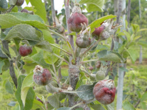
Frost damage occurs when plant tissues are exposed to subfreezing temperatures (Figure 1). However, it is the co-occurrence of other factors that determines the extent of the damage. All these factors should be monitored, and will assist in determining which frost protection method to employ and its duration.
Bud Stage: Regular monitoring of the bud development stage beginning at bud swell will help in determining the actual threat of frost damage. Critical temperatures have been researched and calculated for each bud development stage. For example, in an apple orchard, at 24°F, one can expect up to 90% crop loss at ‘first pink’ stage, but only marginal to zero percent loss at green tip stage at the same temperature. An example of the critical temperature for some of the most common pome and stone fruit crops In New Jersey is available at https://www.canr.msu.edu/news/critical_spring_temperatures_for_tree_fruit_bud_stages Note that the critical temperature for damage at a particular bud stage may vary by 4 or 5⁰F depending on temperatures during the previous few days before the cold event.
Type of frost event: There are two types of frost: Advective and Radiative frost. Advective frost occurs when a large mass of cold dry air moves in from another region and replaces warmer air such as during a polar vortex. The rapid movement of air aids this, and there is generally an absence of an inversion layer, creating the potential for a prolonged event. Frost protection will generally be not effective during an advective frost. Conversely, radiative or radiational frost occurs when there is a rapid loss of heat from the ground, usually with a cloudless open sky, dry air, little wind and the likely formation of an inversion layer. This frost is relatively manageable with frost protection methods.
Inversion Layer: A strong inversion layer can be a source of warmer air, and could have a substantial difference in temperature than that closer to the ground. For this reason, inversions need to be closely monitored.
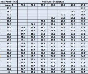
Air Temperature: Frost can occur when the ambient temperature dips below freezing (32°F). The hourly rate of falling temperatures and the lowest forecasted temperature should also be monitored. However, temperature experienced by trees will not necessarily be the same as the reported ambient temperature. To measure the temperature of the flower buds, farmers must take into account the cooling effect of evaporation of the moisture on the trees which is referred to as the wet-bulb temperature. Generally, the wet bulb temperature will be a few degrees lower than the dry bulb temperature except at the 100% RH. Table 1 provides an example of determining wet bulb temperature using the ambient temperature and the dew point. Hand-held and digital psychrometers can be used in the field to determine the wet bulb temperature.
Recently, Knox et al. (2017) at the University of Georgia showed that wet bulb temperature can be simply derived by ‘subtracting one third the difference between ambient temperature and dew point, from the ambient temperature.’ Modern frost alarms measure wet bulb temperature, which can directly transmit real time data to the user’s mobile phone or computer.
Dew point: Dew point is commonly reported as the atmospheric temperature below which water droplets begin to condense, forming dew. At low temperatures, the moisture in the air transitions from a gas to a liquid, as air temperature reaches the dew point. A higher dew point is associated with relatively slow drops in temperature, and vice versa. A lower dew point also generally means surface moisture will evaporate quicker.
Cloud coverage: Clear skies normally result in lower low temperatures than when there is cloud cover trapping radiant energy from the ground.
Wind Speed: Wind will determine the rate of loss of thermal energy. Almost all Frost Protection methods will have reduced efficiency at wind speeds above 10 mph, and are therefore not recommended when winds are above 10 mph.
Effective Frost Protection requires weather stations and sensors for each of the fields you are seeking to monitor and protect. Data from a nearby weather stations may not always be reliable. On-farm weather stations are the most accurate source of weather data, and should be linked with a frost alarm.
Literature Cited:
Knox JA, Nevius DS, and Knox PN. 2017. Two Simple and Accurate Approximations for Wet-bulb Temperature in Moist Conditions with Forecasting Applications. Bulletin of American Meteorological Society. Sept Issue: 1897-1906. https://journals.ametsoc.org/doi/pdf/10.1175/BAMS-D-16-0246.1
Take home message:
- Monitor both your temperature and relative humidity to determine the wet bulb temperature. Remember nighttime temperatures often dip BELOW predicted temperatures, do not GAMBLE.
- Determine what bud stage your tree fruit are at.
- If you suspect you are at risk of a nighttime frost event, monitor the weather report for the likelihood of an inversion layer.
- hink you have a potential for a frost event in your orchard, utilize appropriate frost protection measures.