NJ Depts of Agriculture & Environmental Protection Allow Controlled Open Burning to Protect Crops

(Trenton) [On April 20, w]ith the state expected to experience cooler spring temperatures, the Department of Environmental Protection has agreed with NJDA Secretary Ed Wengryn’s request to allow farmers to do controlled open burning or use specialized torches known as smudge pots to protect flowering crops from damage beginning today, April 20, through Saturday, April 27.

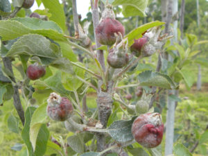
Temperatures are expected to drop to the 30s or below tonight with varying winds through portions of the state. These expected temperatures follow warm temperatures in recent days. Damage from freezing weather now can significantly reduce yields of certain fruits and vegetables that are in the flowering stage.

The DEP and Department of Agriculture are allowing these steps to protect farmers’ livelihoods and to ensure that consumers will be able to enjoy an ample supply of Jersey produce later this year.

The DEP intends to exercise its authority and discretion under the Air Pollution Control Code, N.J.A.C. 7:27, et seq., and other applicable authorities to permit the following procedure for open burning or the use of smudge pots to assist farmers to protect their crops in low temperatures.

Farmers who believe they will need to conduct open burns and/or use smudge pots must provide notice to the DEP’s 24-hour Communications Center at 1-877- WARNDEP (1-877-927-6337).

Notification to DEP does not require the implementation of either technique but ensures proper procedures are followed should they become necessary.

If a farmer does not call DEP in advance but uses either technique, the farmer must notify DEP by 9 a.m. the following day. The farmer will be asked which technique was used.

Farmers must record the incident number provided to them by the Communications Center. The following information is to be provided:

  • Name of the individual making the decision to conduct the open burning/use of smudge pots and name of the farm.
  • Actual street address of the farm on which either technique will be used (no P.O. Boxes).
  • Telephone number of a contact at the farm.
  • Predicted temperature (in degrees Fahrenheit) at the agricultural operation when the technique will be used.
  • Wind speed anticipated when the technique will be used.
  • Predicted hours of open burning and/or use of smudge pots.
  • Materials expected to be burned.
  • At the time of the initial call to the Communications Center, farmers will be given an email address and incident number.

Within two days, they must submit to DEP via this email address the following information:

  • The DEP Communications Center incident number.
  • Ambient temperature (in degrees Fahrenheit) at the time the technique was used.
  • Actual wind speed at the orchard at the time the technique was used.
  • A statement verifying that all restrictions in the open burning or use of smudge pots were followed.
  • The New Jersey Department of Environmental Protection and New Jersey Forest Fire Service caution all farmers and agriculture businesses with respect to the use of open burning in high wind velocity conditions. Please take note that farmers are encouraged to utilize smudge pots for warming as necessary during higher wind conditions. Use of open burning when wind velocity is greater than 5 mph is strictly prohibited, may contribute to wildfire risk, and can carry significant penalties.
  • Smudge pots must be fueled only with either kerosene or No. 2 fuel oil.
  • Open burning can consist only of either the following materials: clean and untreated scrap lumber, felled trees, clippings pruned from trees and shrubs, hedgerows, or firewood. Absolutely no refuse, trade waste, tires or garbage of any type may be added to the authorized open burning material.

The New Jersey Department of Environmental Protection and New Jersey Forest Fire Service caution all farmers and agriculture businesses with respect to the use of open burning in high wind velocity conditions. Please take note that farmers are encouraged to utilize smudge pots for warming as necessary during higher wind conditions. Use of open burning when wind velocity is greater than 5 mph is strictly prohibited, may contribute to wildfire risk, and can carry significant penalties.

###

To learn more about the New Jersey Department of Agriculture, find us on Facebook at www.facebook.com/NJDeptofAgriculture and www.facebook.com/JerseyFreshOfficial or Twitter @NJDA1 and @JerseyFreshNJDA.

Preparing Orchards Against the Frost – Low Tech Strategies

Frost is common in the north-eastern US, however, frost events during bloom, specifically in orchard crops can be economically devastating. Often the cause is a few hours of temperatures below the injury threshold temperature for the developing buds as cooler nights result in the rapid loss of thermal energy. Fortunately, there are several passive methods or low-tech strategies, that can help maintain a slightly higher orchard floor temperature, has the potential to prevent substantial crop loss. [Read more…]

Frost Protection in Orchards – What Should You Monitor?

By Hemant Gohil and Megan Muehlbauer

The weather forecast for the next few days indicate subfreezing temperature in several parts of New Jersey. In fruit crops, such events during the flower bud development, can cause crop loss which could vary from minor loss of quality and quantity to a total crop loss. Recently, frost events seem to be occurring more frequently. These events have been driven by warmer spring temperatures pushing bud growth earlier, making blossoms more vulnerable to frost damage.

What to monitor before active frost protection?

Frost damage occurs when plant tissues are exposed to subfreezing temperatures (Figure 1). However, it is the co-occurrence of other factors that determines the extent of the damage. All these factors should be monitored, and will assist in determining which frost protection method to employ and its duration.

Frost damage in apple

Figure 1. Frost damage in apple following the freeze event in 2010 in Pennsylvania (Photo by R. Crassweller).

Bud Stage: Regular monitoring of the bud development stage beginning at bud swell will help in determining the actual threat of frost damage. Critical temperatures have been researched and calculated for each bud development stage. For example, in an apple orchard, at 24°F, one can expect up to 90% crop loss at ‘first pink’ stage, but only marginal to zero percent loss at green tip stage at the same temperature. An example of the critical temperature for some of the most common pome and stone fruit crops In New Jersey is available at https://www.canr.msu.edu/news/critical_spring_temperatures_for_tree_fruit_bud_stages  Note that the critical temperature for damage at a particular bud stage may vary by 4 or 5⁰F depending on temperatures during the previous few days before the cold event.

Type of frost event: There are two types of frost:  Advective and Radiative frost.  Advective frost occurs when a large mass of cold dry air moves in from another region and replaces warmer air such as during a polar vortex. The rapid movement of air aids this, and there is generally an absence of an inversion layer, creating the potential for a prolonged event. Frost protection will generally be not effective during an advective frost.  Conversely, radiative or radiational frost occurs when there is a rapid loss of heat from the ground, usually with a cloudless open sky, dry air, little wind and the likely formation of an inversion layer. This frost is relatively manageable with frost protection methods.

Inversion Layer: A strong inversion layer can be a source of warmer air, and could have a substantial difference in temperature than that closer to the ground.  For this reason, inversions need to be closely monitored.

Table of wet bulb temp

Table 1. An example of determining wet bulb temp using ambient temp and dew point. Courtesy, Don Smith, Penn State University

Air Temperature: Frost can occur when the ambient temperature dips below freezing (32°F). The hourly rate of falling temperatures and the lowest forecasted temperature should also be monitored. However, temperature experienced by trees will not necessarily be the same as the reported ambient temperature.  To measure the temperature of the flower buds, farmers must take into account the cooling effect of evaporation of the moisture on the trees which is referred to as the wet-bulb temperature. Generally, the wet bulb temperature will be a few degrees lower than the dry bulb temperature except at the 100% RH. Table 1 provides an example of determining wet bulb temperature using the ambient temperature and the dew point. Hand-held and digital psychrometers can be used in the field to determine the wet bulb temperature.

Recently, Knox et al. (2017) at the University of Georgia showed that wet bulb temperature can be simply derived by ‘subtracting one third the difference between ambient temperature and dew point, from the ambient temperature.’ Modern frost alarms measure wet bulb temperature, which can directly transmit real time data to the user’s mobile phone or computer.

Dew point: Dew point is commonly reported as the atmospheric temperature below which water droplets begin to condense, forming dew. At low temperatures, the moisture in the air transitions from a gas to a liquid, as air temperature reaches the dew point. A higher dew point is associated with relatively slow drops in temperature, and vice versa. A lower dew point also generally means surface moisture will evaporate quicker.

Cloud coverage:  Clear skies normally result in lower low temperatures than when there is cloud cover trapping radiant energy from the ground.

Wind Speed: Wind will determine the rate of loss of thermal energy. Almost all Frost Protection methods will have reduced efficiency at wind speeds above 10 mph, and are therefore not recommended when winds are above 10 mph.

Effective Frost Protection requires weather stations and sensors for each of the fields you are seeking to monitor and protect.  Data from a nearby weather stations may not always be reliable.  On-farm weather stations are the most accurate source of weather data, and should be linked with a frost alarm.

Literature Cited:

Knox JA, Nevius DS, and Knox PN. 2017. Two Simple and Accurate Approximations for Wet-bulb Temperature in Moist Conditions with Forecasting Applications. Bulletin of American Meteorological Society. Sept Issue: 1897-1906. https://journals.ametsoc.org/doi/pdf/10.1175/BAMS-D-16-0246.1

Take home message: 

  • Monitor both your temperature and relative humidity to determine the wet bulb temperature. Remember nighttime temperatures often dip BELOW predicted temperatures, do not GAMBLE.
  • Determine what bud stage your tree fruit are at.
  • If you suspect you are at risk of a nighttime frost event, monitor the weather report for the likelihood of an inversion layer.
  • hink you have a potential for a frost event in your orchard, utilize appropriate frost protection measures.